qgis2web: The Story So Far

qgis2web has now been downloaded from the official QGIS plugins repository over half a million times. It’s the sixth most downloaded QGIS plugin of all time. This is a short piece about its history.
qgis2leaf and qgis-ol3
In 2014, Riccardo Klinger created qgis2leaf, which exported QGIS projects to Leaflet webmaps. Around the same time, Victor Olaya created qgis-ol3, which did the same, but exported to OpenLayers webmaps. I got involved with qgis2leaf, as we needed it for work (adding support for WFS, as I recall). I’d never coded in Python or used Qt before, nor used git, but as languages and source control systems go, they’re easier than many.
Riccardo and I continued to work on qgis2leaf intensively, adding considerably to its functionality. It was a really exciting time for me. Learning to code in Python (albeit not at all well) was fine, but what I’d never really experienced before, as an amateur coder, was having the public use code I had written. It was a big step, but a good one, having to deal with issues reported by users I had never met, and never would.
qgis2web is born
In 2015, Paolo Cavallini, now chair of the QGIS Project Steering Committee, got in touch with Victor, Riccardo, and me to suggest that it would help users if qgis2leaf and qgi-ol3 were merged. Both did essentially the same thing, but using a different Javascript webmapping library. We all agreed, and work started on qgis2web. Huge thanks are due to Paolo for the suggestion and support.
qgis-ol3 had a GUI with more functionality than qgis2leaf. Specifically, it had a preview window. This was important, as there was a huge benefit in migrating qgis2leaf to the same GUI. It meant that the proposed merge had advantages for qgis2leaf (as was), as well as for end users. This certainly motivated me, as did Victor’s elegant Python in qgis-ol3.
I lifted all the qgis2leaf code, placed it alongside the qgis-ol3 code, and slightly altered the GUI to allow users to switch between the two. It worked, but really was in essence two plugins side-by-side, with all the duplication that implies.
Improvements and tests
Over time, common functions from the two original plugins were deduplicated, and the code became a little less unwieldy. However, I worried about releasing buggy versions–it did happen once or twice. I had become aware of automated testing, via a service called Travis, hooked into Github. The idea is that, every time a change is made to the source code, a suite of tests is run to ensure that no regressions have been caused.
I thought for some time that this would be an incredibly useful service for qgis2web. With so many variables (layer types, renderers, styles, options), it was already impossible to be rigorous in checking manually that nothing was broken.
With a lot of help from Akbar Gumbira, we finally got it all up and running. It fundamentally changed the reliability of qgis2web across versions, even though wrangling code and reference output files can sometimes be frustrating.
Collaboration and support
Paolo remained a big supporter of qgis2web. As part of a Faunalia contract, he commissioned Nyall Dawson to work on the plugin. This was brilliant news, but the idea of a QGIS core dev looking at my code was also somewhat daunting. Sure enough, Nyall fundamentally refactored the entire plugin, decoupling the GUI from the export process. His work remains to this day, and the plugin is the stronger for it. I must also give credit to both Jürgen Fischer and Matteo Ghetta for their help during this period of development.
It must be said that this work did expose some inherent limitations of qgis2web for some projects. At the end of the day, QGIS, Leaflet, and OpenLayers are very different pieces of software, and the area of functional overlap between the three is significantly smaller than the functionality of each individually. If there were one constant frustration in working on a piece of software used widely by strangers, it would be the struggle to manage expectations, especially given that many users have strong GIS knowledge, but less strong knowledge of the web and its inherent performance limitations.
QGIS3
The changes from QGIS2 to QGIS3 were enormous. Python was upgraded from v2 to v3, and Qt from v4 to v5. In addition, so many things in the QGIS API changed. It was a massive job to produce a compatible version of qgis2web, and it would have been basically impossible for me without the Travis testing environment. However, it all got done, and the concomitant tidying and refactoring of the source code was a massive collateral benefit.
There have been two major version upgrades to OpenLayers and one to Leaflet during qgis2web’s life, and another OpenLayers one is imminent. The work never stops.
Burnout
After the big push to make a QGIS3-compatible version, I did slow down. The eighty-twenty rule kicked in, with remaining issues being either less significant or harder to solve. My attention was also elsewhere (but still using QGIS!). As a result, development slowed down significantly.
Things have picked up again, but I doubt I’ll work as intensively on it again. It’s frustrating, but we’re all human.
Significant help
Many other people have contributed to qgis2web. I specifically want to mention a few here, and apologies to those I miss out through forgetfulness.
Luca Casagrande coauthored qgis-ol3 with Victor. He has continued to support qgis2web, including fixing some problems which totally had me stumped. He also worked on qgis2web with Paolo at a QGIS developer’s meeting.
Nathan Woodrow wrote a module from scratch to convert QGIS expressions into Javascript, and hence make them available in qgis2web. It’s a beautiful bit of code, all the more impressive since I get the impression that Nathan doesn’t really work with Javascript.
Thomas Gratier wrote an OpenLayers plugin from scratch to allow searching by layer attributes. Handling the diversity of possible search sources was a challenge, which he overcame effortlessly.
Per Liedman wrote a Leaflet plugin from scratch to support multiple symbol layers. He also helped a great deal in implementing Leaflet.VectorGrid to support vector tiles.
Iván Sánchez Ortega has been a huge help also in Leaflet.VectorGrid and more generally in Leaflet and vector tile matters.
Ola Kovalev made significant contributions including developing OpenLayers clustering from scratch. Ola is notable in being happy to learn and then implement tests alongside her work, going through the same occasionally frustrating learning process that I had.
Paul Dos Santos implemented overall map styling from scratch. One of my frustrations is not having taken his work further–a fairly simple task, but one which never seems to get to the top of the list.
Martin Boos wrote and maintains the QGIS plugin Vector Tiles Reader, without which none of the vector-tile functionality of qgis2web would be possible.
Ed Boesenberg developed multi-unit measurement in OpenLayers, and also deserves massive thanks for his constant help in answering queries on the qgis2web repo.
New maps
For the first time since it was created, qgis2web has a new output format. Mapbox GL JS excels at rendering vector tiles, and has many other key advantages over Leaflet and OpenLayers. However, it should not be used indiscrimiately, as the other two libraries still have their advantages. In addition, the currently implemented feature-set for Mapbox GL JS in qgis2web is much, much smaller than that implemented for Leaflet or OpenLayers. This will improve over time, but is unlikely to be quick. I hope to write a separate piece investigating the core differences between the three libraries, but that’s a job for another day.
Huge thanks are due once again to Victor Olaya, who has developed bridge-style at GeoCat. It does all the style conversion work, and I can see qgis2web offloading its OpenLayers and Leaflet style conversion code to it in the future. Other projects will then be able to make use of the routines.
A quick note, by way of clarification. Mapbox, the company, provide many services. Mapbox GL JS is one of their products, and is completely open source. qgis2web only exports standalone Mapbox GL JS maps. It doesn’t use any Mapbox services–no hosting, no styles, no data. It’s key to refer to the export format as Mapbox GL JS, to keep it distinct from Mapbox the company and its ecosystem of hosted services. Many thanks to Vladimir Agafonkin for putting me in touch with Kathleen Lu at Mapbox, to ensure that Mapbox are happy with the approach.
Where next?
Developing more functionality for the new Mapbox GL JS exporter is top of the list for me, as qgis2web has reached some level of maturity with its Leaflet and OpenLayers exports (though one day we might get layer groups working properly). There will no doubt be many issues with Mapbox GL JS exports, so handling those will probably also take priority.
More important than these, however, is making qgis2web’s capabilities more readily transparent to the user. We need massively improved error reporting, with an emphasis on feedback on unsupported QGIS features in an export. Alongside this, a compatibility table would also help users decide which export format to choose. With the launch of the new Mapbox GL JS exporter, this has now become much more critical.
And documentation, obviously.
Bellwether
Beyond the code itself, I’m extremely proud of qgis2web for a couple of other reasons. One is having turned code into software–in other words, supporting users, implementing testing, and also promotion, which is a big part of the project. Documentation still lags horribly, but that’s a badge of honour for an open-source project.
Above all, though, I’m proud that qgis2web represents consistent growth in a sector I love–open-source, provider-agnostic software. To my delight, there has been no real plateau in growth:
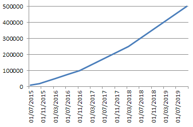
Despite the recent Google Maps price hike, the trend away from non-provider-based webmaps sadly continues. qgis2web tries its best to help those who want to remain truly independent and in control.