OS Zoomstack: first impressions
Ordnance Survey have recently started a trial of a new open UK mapping product, OS Open Zoomstack.
Zoomstack is “a comprehensive vector basemap from a national overview to street level detail”. It comes in various extremely powerful and/or user-friendly formats such as GeoPackage, PostGIS, and vector tiles (both downloadable as an MBTiles file and hosted online and accessible via an API).
I’ve started to take a look at Zoomstack, using QGIS. Before reading this initial review, do take a look at Alasdair Rae’s. It’s very much worth looking at Alasdair’s Mapbox GL examples, as I don’t cover that usage here, and GL exploits the possibilities of this vector data impressively.
Initial impressions
First off, this is a game-changer for UK mapping. Three factors contribute to this:
- it’s vectors
- it’s heavily tailored for different zoom levels
- it’s open
It’s therefore a realistic alternative to OpenStreetMap, assuming that OS continue this approach to open licensing for this dataset. We’ll have to see what they do with the hosted vector tiles — it’s too much to hope that there will be no rate limits.
This won’t be a comprehensive review, as I’m not qualified to comment on many aspects of this product. Specifically, I won’t go into the huge advantages of the different formats. Suffice it to say that these formats will lend themselves to different kinds of user:
- desktop individuals (GeoPackage)
- organizations (PostGIS)
- webmappers (vector tiles)
However, in the spirit of the trial, and of giving feedback (hopefully constructive), here are a few details which could maybe use improvement. I’m not a great user of spatial data, so the majority of this review focuses on cartographic style. Who knows what people will achieve by programmatic use of the data.
Read The Formatting Manual
Please consult the docs before plunging in. I didn’t, and asked some basic (fort. leg. “stupid”) questions they already answered, and even gave feedback which is already covered in the docs. Sorry, OS.
Formats
There is some discrepancy in both the layers and styles. There are slightly different layers in the GeoPackage and the MBTiles vector layers. I don’t know what real difference this will make in practice, so it would be good to know which layers will make it into the final product, and hopefully see consistency between the formats. Similarly, OS have published stylesheets for Zoomstack, including multiple styles in GL JSON format. It would be good to have the alternative styles in the other formats (such as QML).
Performance and functionality
I’m getting some rendering freezes using the GeoPackage in QGIS across a network. I don’t know if this is a QGIS issue, or whether any improvements can be made to the GPKG itself.
The MBTiles vector tiles work well in QGIS, using the plugin Vector Tiles Reader. The GL JSON styles don’t import, but you can apply each layer QML individually:
The vector tiles API does not work with QGIS Vector Tiles Reader. This seems to be caused by a familiar problem with the interpretation/implementation of the MBVT spec regarding TileJSON/metadata. I don’t know the full details, but you can see some discussion of it in a Vector Tiles Reader issue about Geoserver vector tiles.
Update: Charley Glynn has shown me how to get the hosted tiles working via the API with QGIS Vector Tiles Reader, so the previous paragraph is incorrect. Thanks, Charley!
Style and cartography
The rest of this review will look at specific cartographic styling issues. Three fundamental points must be borne in mind:
- I’m not a cartographer, and you must reach your own conclusions
- these issues are very specific, and solving them in a way which does not break other instances might not be possible
- since this is a vector dataset, we can all alter the styles ourselves — the following points therefore apply to the default styles supplied by OS (we all know how often default styles get used, so improving them as far as possible is surely A Good Thing)
Settlement labels
The labelling of settlements is perhaps too heavy:
Knocking back to a paler grey, and unemboldening non-cities is an improvement, together with making a greater size differential:
Perhaps the reduction in legibility is too high a price to pay — opinions welcome.
Update: I’ve just tried reapplying the QML to the text layer, and this time, the text is not bold. I have no explanation, though perhaps the fact that first time round, I failed to install the supplied fonts before applying the styles might have caused the issue. The main point is that the paragraphs above might well be irrelevant.
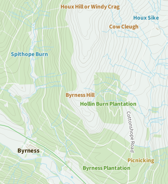
Some zoom levels seem to fall between label visibility thresholds. This becomes apparent in rural areas (my own interest):
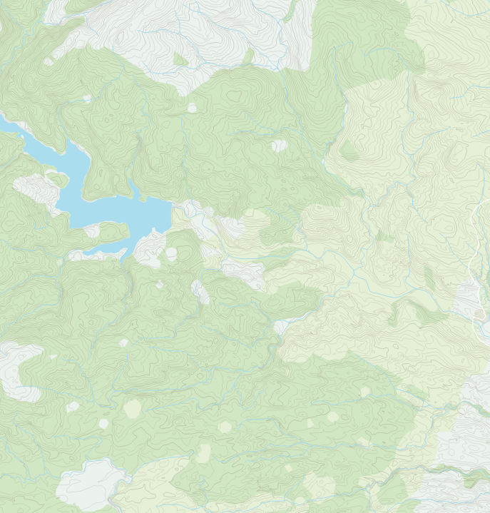
I’m not sure if this can be tweaked without cluttering denser areas. As an aside, though, this map really shows off this dataset’s design. It’s simply beautiful, and the contours add hugely to the potential for rural maps.
Waterline labels
Zoomstack has a dedicated Names layer, rather than using features’ properties for labels (roads being a notable exception). This is presumably to retain some information for OS’s proprietary datasets, but it does makes some things difficult.
An example is the labelling of the Waterlines layer:
The labelling in this image suffers from lack of type differentiation — only colour differentiates settlements from forests, landscape features, and waterlines. If the latter could be labelled along the watercourse (as the roads are), this would improve things no end. I’m not sure we’re likely to see that improvement, though.
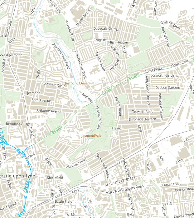
Roads
A few issues are apparent at Swan House Roundabout in Newcastle:
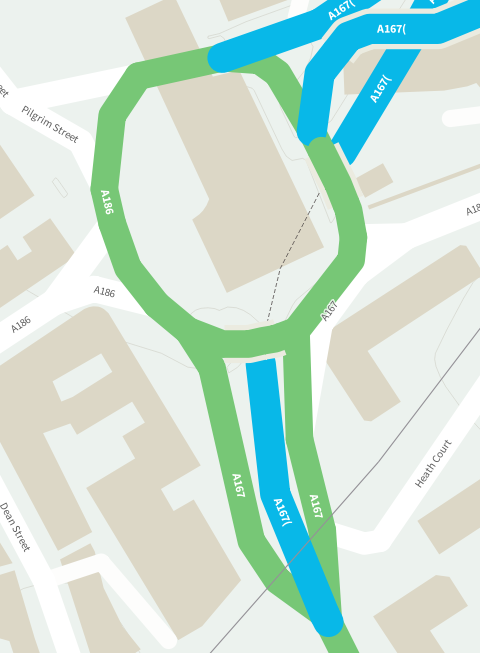
- the labels for A roads with motorway status have been truncated
- the merging of different classes of road doesn’t quite work (possibly fixable by tweaking the stacking order of the symbols, but whether this can be achieved generally, rather than in this specific case, I don’t know)
- road line caps should be square, not curved (see the minor white dead end, top-right)
- the motorway tunnel would benefit hugely from a dotted case instead of a centreline — as it stands, it’s not immediately clear what road layout this represents
Conclusion
You can tell by the minor level of detail I’ve discussed here how successful Zoomstack is. I’m incredibly impressed, some views being comparable to some well-known OSM-based prerendered raster tilesets. I’ve not even begun to try styling things myself, but I can’t wait to see what people build with this.
Amazing work, everyone.